Check our latest news
Product Update
AirData launches cloud recording and 10-minute rewind for drone live streaming
September 10, 2026
•
x min read
AirData has launched Stream Recording and Rewind for AirData Live Streaming, giving drone programs more control over live video during an operation and after the flight.
The update includes three new capabilities:
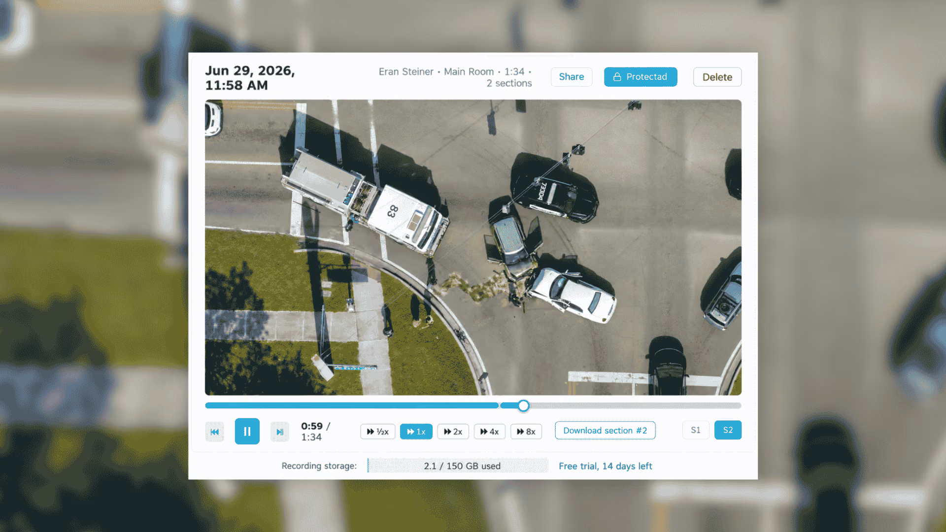
- 10-minute Rewind: Jump back through up to the previous 10 minutes while the stream remains live.
- Stream Recording: Save live streams to your AirData account for playback and review later.
- Capture what happened before recording started: Start a recording after an event occurs and include up to the previous 10 minutes.
Together, these features help teams recover moments they missed, save live video for later review and preserve a copy of the stream independently of the aircraft.
As drone programs expand into Drone as First Responder (DFR), dock-based inspections and beyond visual line of sight (BVLOS) operations, the pilot, aircraft and person making decisions may all be in different places. The person who needs to see the video may not be watching at the exact moment something important happens.
In a live operation, the most important moment does not wait for the right person to start recording. Especially on longer ops, the operator is not recording the whole time, so a key moment can go uncaptured. That's the problem we built this to solve. Teams can look back while the mission is still unfolding, preserve a second copy off the aircraft, and do it across any drone brand, dock, or flight app they already use.
- Eran Steiner, Founder and CEO, AirData
Go back without leaving the live stream
With 10-minute Rewind, authorized viewers can move back through an active stream, review what the drone already saw and then return to live.
For a public safety program, that could mean an analyst or commander joining after the drone has already reached the scene. Instead of relying on someone else to recap what happened, they can rewind the original footage and catch up while the incident is still underway.
The Huntsville Police Department has already been using the new capabilities as part of its drone operations.
We have been using AirData Live Streaming for years, and Record and Rewind has given us a tremendous new tool to capture events as they unfold. Our analysts are now not only able to watch the live feeds, but can pause, rewind, zoom and capture critical details that may have been missed as events unfold. This gives the analyst more control over the data as it comes in.
- Chad Tillman, UAS Coordinator, Huntsville Police Department, Huntsville, Alabama
The same challenge appears in remote inspection workflows. If an engineer joins after the aircraft has already passed an area of interest, they can look back at the footage immediately instead of asking the pilot to reposition the drone or waiting until after the flight to review onboard video.
Start recording after the important moment happens
Not every stream needs to be recorded from beginning to end. But sometimes the event worth saving happens before anyone realizes a recording is needed.
AirData can start a recording that includes up to the previous 10 minutes of the stream. That means the recording can preserve the lead-up to an incident, anomaly or other important event instead of beginning only when someone presses record.
Programs that prefer to record every stream can also enable automatic recording whenever a stream goes live. Pilots can start and stop recordings from the AirData mobile app, while administrators manage recording settings at the account level.
Preserve a second copy off the aircraft
Because Stream Recording writes video to AirData as it streams, the saved copy is not dependent on recovering the aircraft or its onboard storage.
If a drone is lost or damaged, or an SD card fails or is unavailable, the streamed recording remains in the AirData account.
Recordings are stored in the account's configured AirData region, including regional infrastructure outside the United States. Administrators can set retention periods so recordings are automatically removed according to the organization's policy.
Recordings can also be shared with controlled access using a PIN, expiration date and QR code.
Record streams from docks, encoders and third-party flight apps
Stream Recording is not limited to video sent from the AirData mobile app.
AirData can record incoming RTMP, RTSP and SRT streams, including feeds from dock-based systems and third-party encoders. Organizations can use the same recording and rewind workflow across different aircraft, flight applications and remote operations without requiring a specific drone ecosystem.
For teams operating mixed fleets or expanding dock-based programs, the recording workflow follows the stream rather than the aircraft brand.
Supporting the next phase of BVLOS operations
The FAA's proposed Part 108 framework for routine BVLOS operations would place greater responsibility on the operating organization and calls for detailed records covering flights, aircraft, personnel, maintenance and training.
As drone operations become more remote, cloud recording provides additional redundancy by preserving mission video independently of the aircraft and its onboard storage.
Stream Recording keeps mission video alongside AirData's existing flight, aircraft and personnel data. Recorded streams can support post-incident review, internal investigations, training and stakeholder briefings without relying solely on media that remained onboard the aircraft.
Try Stream Recording and Rewind
Stream Recording and Rewind is available for AirData Live Streaming customers.
Existing Live Streaming customers can request a trial directly through the AirData web app.
Blog
AirData surpasses 65 million drone flights as the FAA's BVLOS rule awaits publication
August 25, 2026
•
x min read
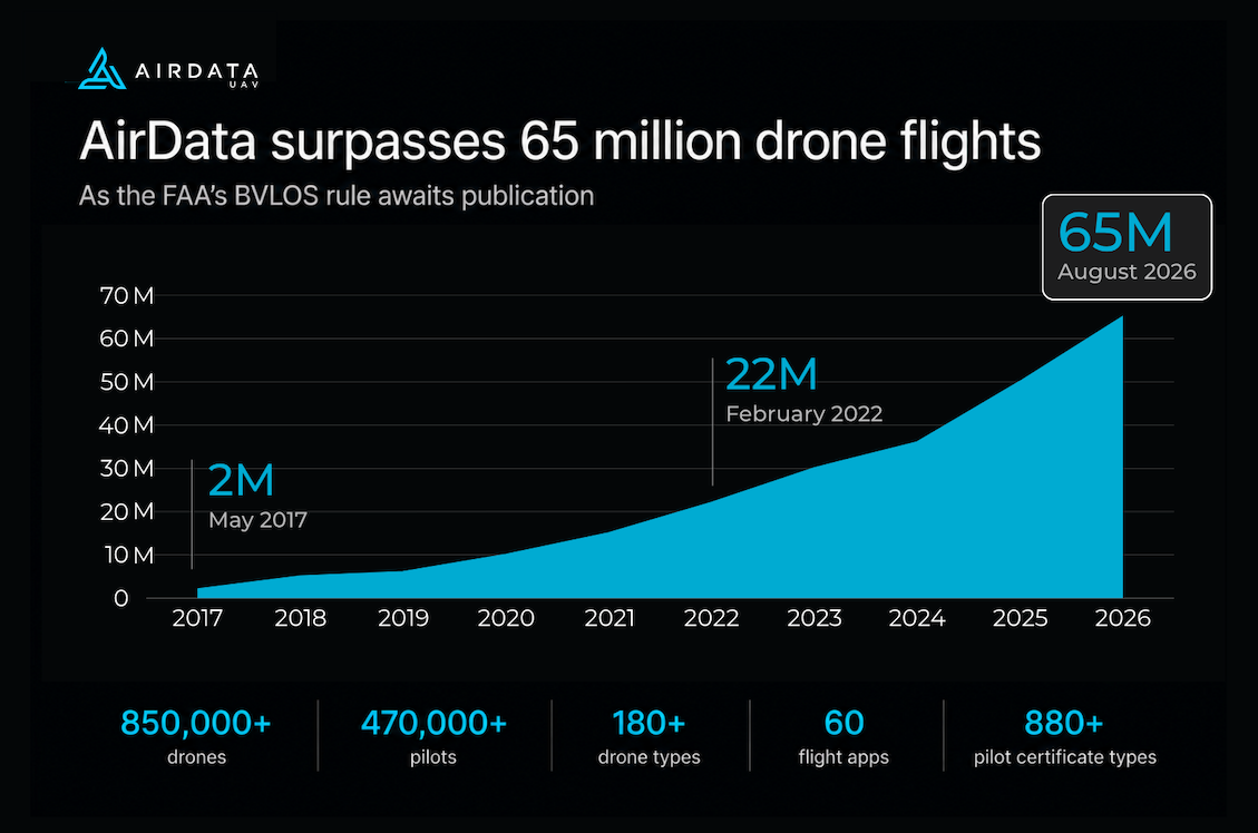
AirData has passed 65 million drone flights, covering more than 850,000 drones and 470,000 pilots worldwide. The milestone comes as the FAA's final Part 108 rule for routine beyond visual line of sight (BVLOS) operations sits with the Office of Information and Regulatory Affairs, where it has been under review since July 10 and where it takes its last major step before publication.
The pace has picked up. AirData passed 50 million flights in May 2025 and has added 15 million in the fifteen months since, a million flights a month. Some of that comes from existing programs getting larger. Some comes from organizations that now run drones as routine infrastructure instead of as pilot projects.
Those organizations are the ones Part 108 would govern. The rule moves accountability for a flight from the individual remote pilot to the operating organization, which becomes responsible for showing that its personnel are qualified, its aircraft are airworthy, and its operations follow approved procedures. It requires the organization to maintain a flight data collection system, keep qualification and training records for its people, and show that the person overseeing a flight is current on the aircraft being flown. Flights, personnel, maintenance, and incidents are the categories the rule names, and they are the categories AirData has captured for a decade.
Scale is also what makes the analysis possible.
Sixty five million flights is not a vanity number for us. It is why we can tell an operator that one battery is aging differently from the other nineteen packs of the same model on the same duty cycle. No single fleet is large enough to produce that comparison on its own. - Eran Steiner, Founder and CEO, AirData
Those flights come from 180+ drone types and 60 flight apps, so they reflect mixed fleets rather than a single vendor's ecosystem. AirData analyzes every battery cell after every flight and recognizes more than 880 pilot certificate types worldwide for currency tracking.
Pacific Gas and Electric flies across a 70,000-square-mile service area in California under a BVLOS waiver, and uses AirData to automate the flight, personnel, and maintenance evidence that waiver requires. Its program is an early example of the organization-level documentation Part 108 would apply more broadly.
Implementing AirData has centralized our flight logging, compliance reporting, and maintenance tracking in an automated and proactive manner. This allows our pilots, technicians, and administrators to focus on their respective missions with confidence that regulations are being followed. - Kellen Kirk, Manager of UAS and Fixed Wing Operations, Pacific Gas and Electric
AirData is a member of the Commercial Drone Alliance and has published a business readiness guide for the rule, The AirData Blueprint: Operational readiness for the Part 108 era. AirData will exhibit at Commercial UAV Expo, booth #914, September 1 to 3 at Caesars Forum, Las Vegas.
Blog
AirData Enterprise
August 3, 2026
•
x min read
The data and operations layer for commercial drone programs
Pilots, aircraft, missions, and compliance in one system, across the complete flight.
View instant interactive demo
What AirData does: Across any mix of hardware, AirData Enterprise captures the plan, the flight itself, and the analysis that follows. When a client or an auditor asks about a flight from last quarter, nobody has to go digging for it.
From flight plan to final report
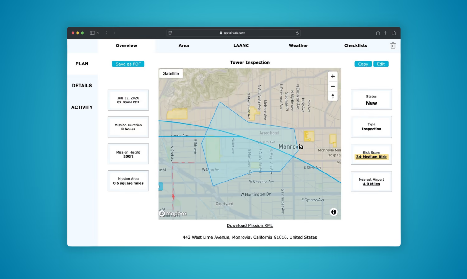
1 - Before the flight
A manager assigns the crew, aircraft, and airspace before anyone leaves for the site. Pilots open the mission on their phone already knowing the plan, and an expiring credential gets flagged before someone flies on it.
- Mission planning → with airspace authorization
- Ok to Fly checks → weather and conditions
- Certification tracking → 550+ types worldwide
2 - In the air
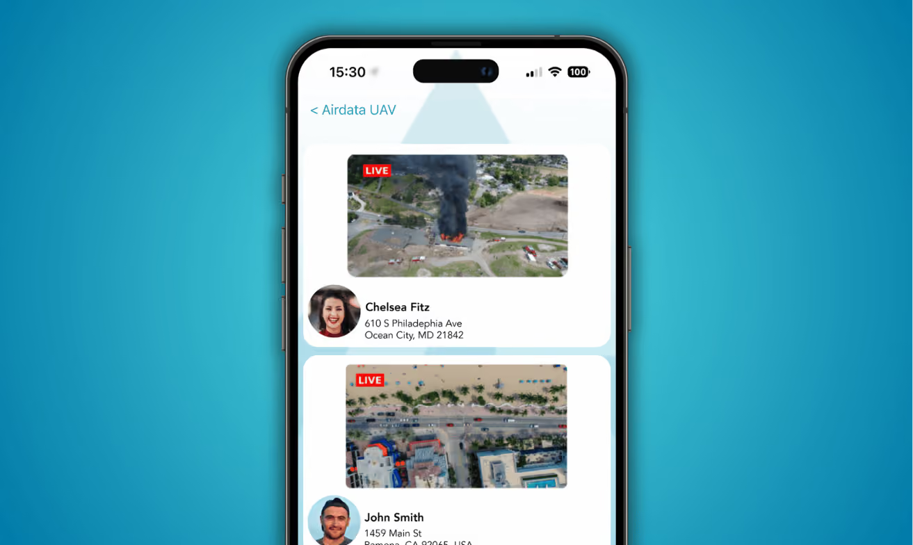
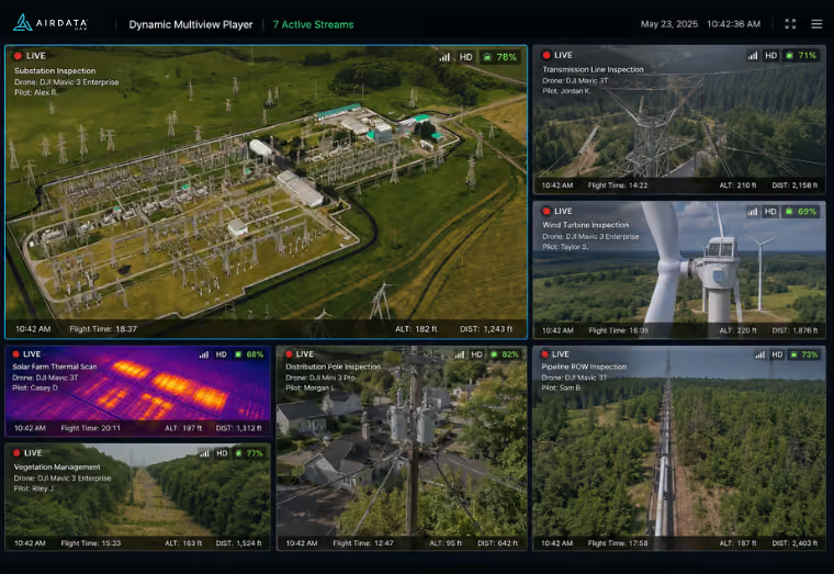
A supervisor in the office, or a client at their desk, can watch what the pilot sees. Several flights can run side by side in one view, so one person keeps track of a whole team without leaving the office.
- Live streaming → sub-second, add-on
- Browser-based viewing → PIN protected, no account needed
- Multiview dashboard → feeds appear as pilots go live
3 - After landing
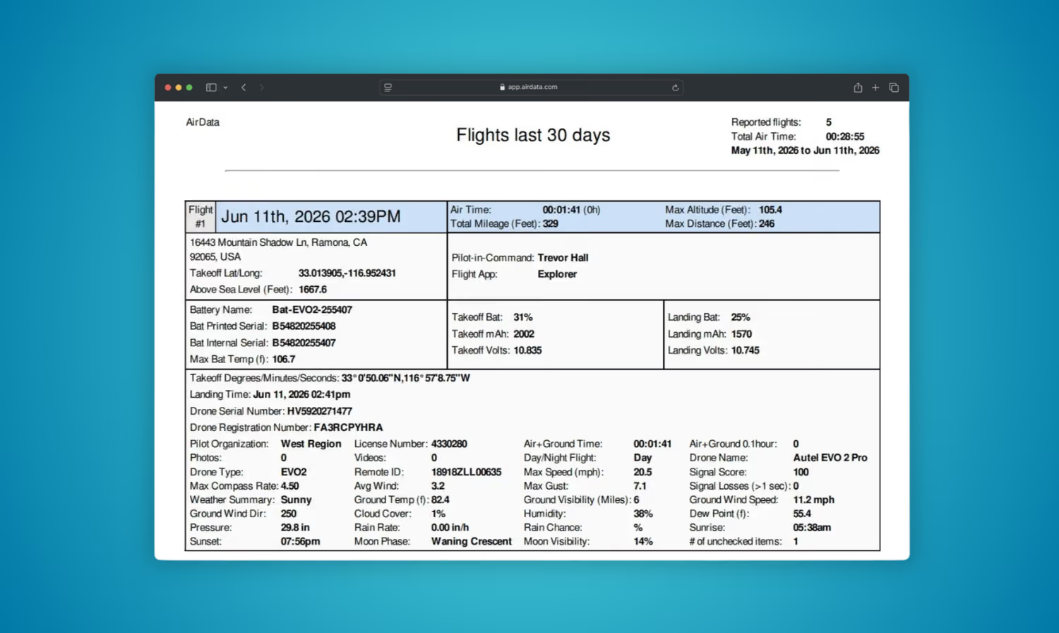
The pilot packs up and the analysis is already running. Weeks later, when an insurer or a client asks for records across a date range, you filter and export instead of rebuilding the file by hand.
- No manual data entry → logs sync or upload directly
- Fault and threshold alerts → as each flight syncs
- Compliance reports → for authorities in any region
Why programs choose AirData
Fewer aircraft lost to problems you could have caught
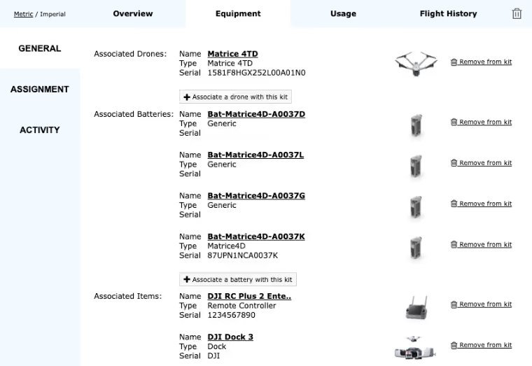
Battery and mechanical faults show up in the flight data as they develop, so an aircraft can be grounded before a problem becomes a loss. Airframe hours and battery cycles are tracked per asset, so service is scheduled ahead of a failure.
Hours back every month
Timestamp, location, pilot, aircraft, and mission type are captured without anyone typing them in, so a report that used to mean an afternoon in spreadsheets comes out in seconds.
Compliance ready before anyone asks
Certifications, waivers, and registrations are flagged before they lapse, and the evidence behind every flight is already assembled. Built for the Part 108 era in the US and the equivalent frameworks emerging with civil aviation authorities elsewhere.
Keep flying the drones you already own
180+ drone models, 40 manufacturers, 35+ flight apps. No hardware changes, no change to how your pilots fly, and no lock-in when you add or replace aircraft.
"Implementing AirData has centralized our flight logging, compliance reporting, and maintenance tracking."
— Kellen Kirk, Manager of UAS and Fixed Wing Operations, PG&E
Add-ons
See the full Enterprise feature list
See what your program looks like in AirData
Programs use AirData to fly safer, prove compliance, reduce risk, and scale. Walk through it yourself, or tell us how your program runs.
Talk to our team
View instant interactive demo
Not running a multi-pilot program yet? Browse all plans
%201.avif)
Blog
FAA Part 108 Explained: Everything Drone Operators Need to Know in 2026
July 20, 2026
•
x min read
FAA Part 108 is the most significant proposed change to drone regulation since Part 107 came out in 2016. It sets up a formal framework for Beyond Visual Line of Sight (BVLOS) operations, something that has been legally possible through waivers but practically difficult to scale. This post covers what the rule proposes, who it affects, what the industry is pushing back on, and what operators should be doing right now.
What Is FAA Part 108?
FAA Part 108 is a proposed rule focused on highly automated drone operations. The goal is to replace the current system of individual waivers and exemptions with a standardized, scalable framework that lets operators plan and run routine BVLOS flights. Operators would still need approval for each operation, much like in crewed aviation, but without going through the arduous waiver process each time.
Right now, BVLOS flight is legal under Part 107 only with an FAA granted waiver. Getting one takes time, the scope is limited, and other operators can’t easily build repeatable programs around them. Part 108 is designed to fix that. It covers a wide range of use cases: long-range delivery, infrastructure inspection, precision agriculture, public safety, surveying, and more.
BVLOS Today — Part 107 Waivers
1. Apply for a waiver
2. Wait through case-by-case FAA review
3. Receive a narrow, one-off approval
4. Repeat for every new operation
BVLOS Under Part 108
1. Qualify once for a permit or certificate
2. Get streamlined per-operation approval
3. Run routine, repeatable BVLOS missions at scale
The proposed rule runs more than 600 pages and is the most substantial update to commercial drone regulation since Part 107 was introduced in 2016.
Why Does Part 108 Exist? A Brief Timeline
• 2021 — BVLOS Rulemaking Committee Formed
The FAA formed the BVLOS Aviation Rulemaking Committee (ARC) to address the need for updated regulations enabling more complex drone operations.
• 2022 — ARC Report Released
The BVLOS ARC delivered a 381-page report with 70 detailed recommendations for the new Part 108 rule.
• 2024 — FAA Reauthorization Act
Congress mandated the creation of a Part 108 rule to address BVLOS operations, reflecting urgency to establish standardized regulations across the industry.
• June 6, 2025 — “Unleashing American Drone Dominance” Executive Order
President Trump signed Executive Order No. 14307, directing the FAA to issue a proposed rule enabling routine BVLOS operations and finalize within 240 days.
• August 7, 2025 — NPRM Published
The Part 108 Notice of Proposed Rulemaking was officially published in the Federal Register (90 FR 38212, Docket FAA-2025-1908), opening a 60-day public comment period.
• October 6, 2025 — Comment Period Closed
Nearly 3,100 comments were submitted. More than half addressed the proposed right-of-way rules.
• January 28, 2026 — Limited Comment Period Reopened
The FAA reopened comments on the proposed right-of-way and electronic conspicuity requirements, the most contested issues in the proposal. The reopened window closed February 11, 2026.
• July 10, 2026 — Rule Sent to OIRA for Final Review
The final rule reached the Office of Information and Regulatory Affairs (OIRA) for review, its last major stop before publication. OIRA targets a July 2026 release and its review of significant rules can run up to 90 days, so timing beyond that window is still to be confirmed.
• Next — OIRA Sign-Off and Final Rule
Once OIRA completes its review, the rule can publish in the Federal Register, followed by an effective date (typically 30 to 60 days out) and staggered compliance dates. Allowing for the OIRA review window, a published final rule is most likely in late 2026 or into 2027, with full implementation expected a year or so after that.
Part 107 vs. Part 108: What’s the Difference?
| Part 107 | Part 108 | |
|---|---|---|
| Who it's for | Individual remote pilots | Organizations / operators |
| Line of sight | Visual line of sight required | Allows for BVLOS flight |
| Max drone weight | 55 lbs | Up to 1,320 lbs |
| Authorization | Per-flight waivers for BVLOS | Operating permit or certificate |
| Responsibility | Individual pilot | The operating organization |
| Automation | Pilot manually-controlled | Supports highly automated flight |
The Two Authorization Levels Under Part 108
The proposed rule requires operators to obtain one of two authorizations before conducting BVLOS flights:
Operating Permit
For lower-risk, limited-scale operations:
• Package delivery
• Agriculture monitoring
• Rural infrastructure inspection
• Training and recreational BVLOS
Operating Certificate
For higher-risk or complex operations:
• Larger aircraft or fleets
• Operations over populated areas
• High complexity highly automated missions
• Requires Safety Management System (SMS)
New Roles: Who Does What Under Part 108?
One of Part 108’s core changes is moving compliance responsibility from individual pilots to the operating organization. Two new roles are required under the proposed framework:
Operations Supervisor: Responsible for the overall safety and logistics of every flight operation. This person is the final authority on safe and secure operation of all unmanned aircraft. Qualified through training, experience, or demonstrated expertise.
Flight Coordinator: Handles tactical oversight of individual aircraft during live operations, monitoring flights in real time and intervening when needed. Each flight coordinator can oversee multiple aircraft simultaneously.
Technical Requirements: What Drones Need to Fly Under Part 108
Part 108 sets performance-based standards rather than prescriptive rules. Key technical requirements include:
Electronic Conspicuity: Electronic conspicuity refers to technologies that allow aircraft to digitally broadcast their position and identity so other airspace users can detect them. Routine BVLOS operations require that all aircraft and traffic management systems understand who is operating nearby, maintain safe separation, and document compliance with emerging right-of-way and detect-and-avoid requirements.
Remote ID: Drones must broadcast their identity and location at all times while operating. This is the most common form of drone electronic conspicuity.
Detect-and-Avoid (DAA): Drones must yield right of way to crewed aircraft broadcasting via ADS-B (another form of electronic conspicuity), using onboard or ground-based detection systems.
Redundant Systems: No single power or propulsion failure can result in loss of flight control.
Conformance Monitoring: The aircraft must continuously compare its actual position and behavior against its declared operational intent. When deviations are detected, the system must alert the operator and, where applicable, other aircraft in the area.
Cybersecurity Protection: Systems must resist electronic interference and unauthorized access.
Anti-Collision Lighting: Must be visible from 3 statute miles.
Airworthiness Acceptance: Manufacturers are responsible for demonstrating airworthiness rather than the FAA issuing a type certificate.
What Should Drone Operators Do Right Now?
1 - Audit your current operations. Figure out which missions would fall under Part 108 rather than Part 107. Long-range inspections, delivery routes, dock-based missions, and anything highly automated should be your starting point.
2 - Review your documentation practices. Part 108 has broad requirements covering pre-flight, in-flight, and post-flight records. Your logs, checklists, and maintenance history need to be complete and easy to produce on request.
3 - Check your fleet’s technical readiness. Does your current hardware support Remote ID, ADS-B detection, and the redundancy requirements in the proposed rule? Better to find gaps now than during a compliance review.
4 - Think through personnel roles. Who in your organization could qualify as an Operations Supervisor or Flight Coordinator? What training would they need? These aren’t roles you want to staff reactively.
5 - Get your compliance infrastructure in order. Part 108 will require maintenance records, pilot currency tracking, operational safety management, operational histories, and documented risk management procedures. AirData’s platform covers all of this today. Operators who have it organized before the final rule publishes will be in a much better position to move quickly.

AirData Is Already Built for What Part 108 Requires
AirData is a comprehensive system of record for the flight, maintenance, and compliance data a drone program depends on. It keeps one authoritative source of truth across your operation, so records stay complete, audits are easy to support, and conflicting information never slows you down. Without a single trusted record, a growing drone program is flying blind. Part 108 will require operators to maintain detailed, auditable records for safety, maintenance, training, and more, and AirData gives you the structure to handle that volume as your program scales.
The platform automates the work Part 108 will demand: compliance documentation creates itself, digital checklists and flight logs are captured automatically, pilot currency and maintenance records stay current, and fleet-wide analytics give program managers clear visibility into operational risk. Part 108 changes more than what you can fly. It changes how your entire operation is documented, managed, and proven compliant. Operators who build that record now will have a real advantage when the rule takes effect.
AirData is trusted by more than 460,000 pilots across 232 countries and territories, with 64M+ flights and roughly 10 trillion data points behind it, the largest known dataset in commercial drone operations. As a member of the Commercial Drone Alliance, we’re helping shape the standards coming out of the BVLOS rulemaking process.
Start an enterprise trial at app.airdata.com/enterprise
Build the record Part 108 will require, before the rule lands: Download the Part 108 Guide
Blog
News
AirData and Chula Vista PD Bring Flight Transparency to Community
October 5, 2021
•
x min read
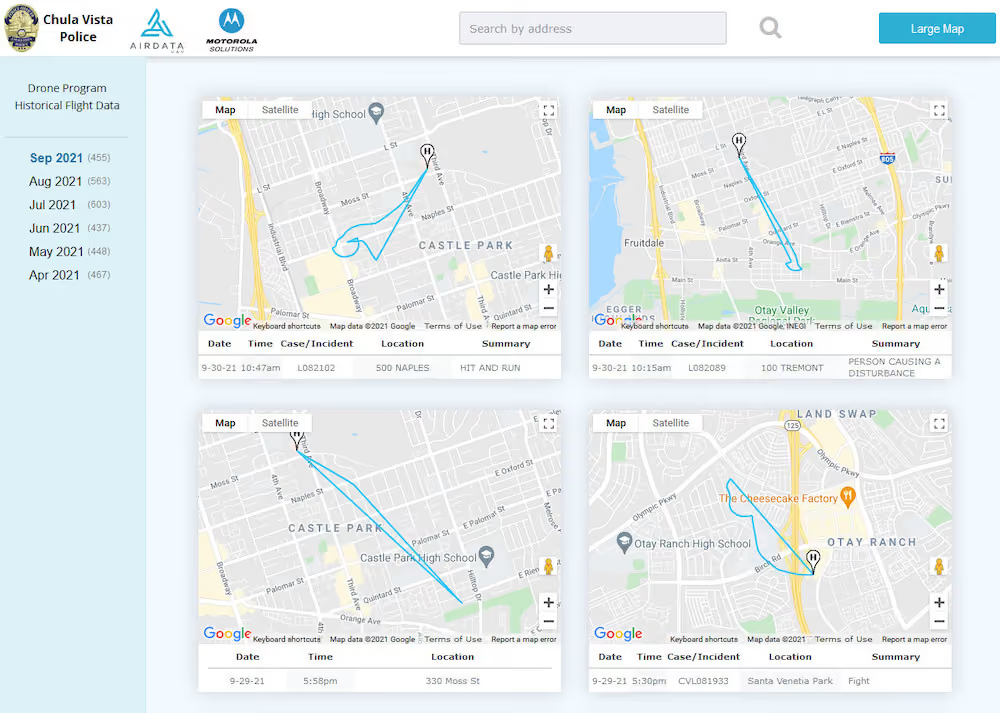
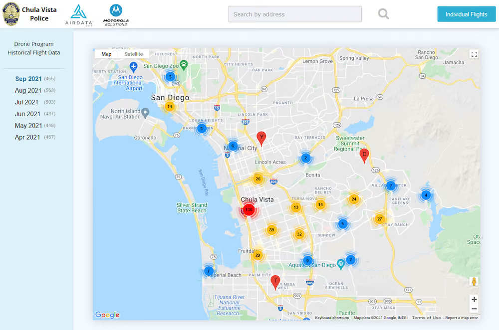
We are excited to collaborate with the Chula Vista Police Department (CVPD) to bring flight transparency to the public. AirData now offers Chula Vista residents the ability to view and understand the exact location, flight path, and purpose behind each police drone deployment.
CVPD's Nationally Recognized Drone Program
CVPD has been an innovator in the industry bringing its drone program to light in October of 2018. Since then, the program has continued to expand its capabilities and now provides additional transparency to constituents through the partnership with AirData.
Chula Vista offers its residents an open AirData-driven web page, enabling the public to be well informed of drone-related law enforcement activity. The CVPD Drone Program Historical Flight Data page is available here: https://app.airdata.com/u/cvpd
“Transparency and accountability are key components in the success of our drone program which has been an invaluable tool in maintaining the safety of our officers and the public. We pride ourselves on ensuring the public has access to our drone flight information in upholding the trust of our community.” - Chief Roxana Kennedy, Chula Vista Police Department
AirData Allows CVPD's Officers to Focus on the Mission
With a seamless and simple way to track and manage all of the flight data from their missions, officers can focus on what’s important - keeping the community safe with drone technology, letting the integration provide effortless data collection and automatic reporting. Powering the time-intensive tasks to run in the background will enable police departments to focus on keeping the community safe.
AirData UAV is an industry leader in drone fleet management and offers a robust integration for departments looking to benefit from a comprehensive drone program.
About Chula Vista Police Department
The mission of the Chula Vista Police Department’s UAS Program is to provide airborne support to police operations in a safe, responsible, and transparent manner to preserve the peace, reduce response times and increase the quality of life in Chula Vista.
To learn more about CVPD’s Drone Program, click this link: https://www.chulavistaca.gov/departments/police-department/programs/uas-drone-program
Blog
DJI and AirData Set Industry Standards for Drone Maintenance
September 23, 2021
•
x min read
AirData and DJI are revolutionizing how we think about drone maintenance with automatic tracking of your aircraft's service and comprehensive maintenance guides.
Read more about our new integration on the DJI Enterprise Blog.
AirData Maintenance - Overview
An integral part of AirData's end-to-end fleet management solution is maintenance tracking.
For a safe, well-informed pilot it is important to have properly maintained equipment. Today, when your flight logs are uploaded to AirData, we do the heavy lifting of tracking your equipment's status, so you don't have to.
AirData tracks your equipment's air time, the number of flights, and how many times your battery has been charged. We are then able to send you email Alerts when maintenance is due on your drones and batteries.
Ready-made service templates allow for the accurate and timely completion of maintenance items.
As new regulatory requirements for additional maintenance logging have been introduced, we're busy enhancing our product to help you meet compliance needs.

AirData and DJI Set New Standards With DJI's Enterprise Maintenance Service
With the high level of sophistication matching DJI's rapidly evolving drone technology, the proper care provided by DJI's Enterprise maintenance is crucial for equipment longevity and operational readiness. AirData and DJI worked closely to make it easier than ever for pilots to maintain their DJI Enterprise drones.
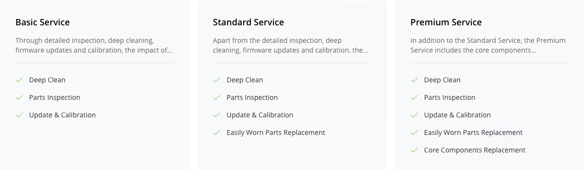
AirData’s maintenance for DJI's Enterprise drones is now based on DJI maintenance standards and service recommendations. AirData has curated four new service types that are specific to DJI's Enterprise drone lineup — each new service crafted to parallel the tiers of DJI's Maintenance Program.
DJI's Maintenance Program
AirData provides drone program managers with a powerful fleet management tool that automates manual processes, increases data visibility, enables collaboration, and improves the reliability of your drone program. The integration of DJI Maintenance adds enterprise-level upkeep expertise into the equation. Together, DJI and AirData are on hand to help program managers work smarter, safer, and with greater efficiency." -DJI
Read more about our new integration on the DJI Enterprise Blog.
To learn more about how AirData can help you efficiently manage your fleet and properly maintain your drone, please contact us.
The integration is currently available for customers in North America and Europe, with more regions becoming available soon. If you do not see the four new service types listed on your AirData account yet, you may not be located in a region that is eligible for DJI's Maintenance Program.

Case Study
AirData Helps Megilot Rescue Drone Team Save Lives - Use Case
April 22, 2021
•
x min read
Contributed post by Ariel Zentner, head of Megilot Rescue Drone Team. This incredible organization compiled of only volunteers utilizes drones as a force multiplier for their team. We thank Ariel for this write-up on using drones and AirData for Search and Rescue!
AIRDATA UAV helps save lives
The Megilot Rescue team operates in the North of the Judean Desert. Our goal is to save lives and assist travelers and hikers in need of help, either due to injury, medical conditions or simply getting lost (which can easily lead to the other two).
The whole unit from top to bottom is volunteer-based, we get called out to an average of 100 rescues a year. The unit currently consists of approximately 90 volunteers, who mostly live in or near the North Judean Desert.
About five years ago we discovered the extraordinary value of drones as a game-changing tool in the rescue business. We use drones for a variety of missions: searching for people, command and control of our teams, finding and planning complex routes, a visual aid when rappelling in complex terrain, and also for documenting and sharing our experiences.
We have built a professional drone team, which helps us achieve all the above goals. Our team consists of approximately ten pilots, half of whom are officially certified and half who have yet to pass official certification, and about 7 active drones. Over time we have developed quite an expertise at flying in tight conditions, very low and close to the ground, and dealing with frequent disconnection and interruptions due to steep descents and ascents. We train regularly, and have successfully used drones in numerous rescue missions, some of which were quickly handled thanks to the drones. A search mission which in the past took us hours of footwork, can sometimes be solved in minutes if we have a drone at the right spot.
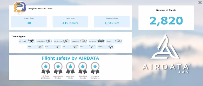
Due to our volunteer-based structure, most drones aren’t personal (i.e. assigned to a specific pilot), rather we all share them according to need and availability. Each mission could have different pilots flying different drones. We must have good documentation and control over our fleet of drones and pilots, or else there will be a big mess. Requesting each volunteering pilot to manually fill out a lengthy form with all the flight details, post-flight, was too much to ask from people and led to it just not happening. We felt we needed a professional system to keep track of all the information.
Our research led us to AIRDATA UAV which we found to be a good, simple, user-friendly, yet powerful way to keep track of all the various pilots and equipment. After using it for a few years we have learned to trust it and rely on it to the extent that we honestly don’t know how we can operate without it.
All our logs are synchronized automatically to AirData without any user intervention, so all our pilots need to do is sync up their tablet device (usually via the DJI sync).
We group our flight by subject an actual rescue mission, a team training mission, or just our pilots performing personal practice. This helps us keep things tidy and easy to access and reference. We tag our flights with tags such as rescue/training/safety issues/etc. So that we can easily get a report of only the group of flights we’re interested in.
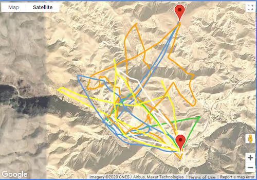
The grouping also really helps us visualize a mission and see what ground was covered during a SAR mission, and which still remains unsearched. Due to our terrain's great variance in height, and narrow ravines, it’s crucial that the pilot stands in the correct position in order to achieve the required coverage for the mission. We use these diagrams from previous flights as a reference to what coverage is possible from a specific spot, that way when a real rescue comes in we can choose our piloting positions cleverly, in order to best suit the mission at hand.
We regularly check the device maintenance and battery tabs, to see how our equipment is performing and if anything needs to be taken into notice.
Since we fly in challenging terrain, we stretch the drone's capability to their limits, and commonly encounter signal loss and other unwanted behaviour. During flight case investigations we often go back and look at the informative General->Notification tab, and HD Flight Player. We analyse which unwanted events occurred during the flight and try to understand what may have caused them, by cross-checking the pilot’s location, drone position and stick inputs. With this information we learn how to avoid such cases in the future, and how to get better at what we do.
All in all, we thank AIRDATA UAV for such a great product, and for helping and supporting us whenever we need. We find them professional, courteous, and willing to help, and really enjoy using their product.
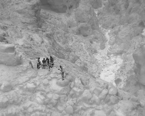
A short video showing the exciting moment when our rescue team reached the people in distress: https://youtu.be/vKPF6peyUl8
The people were discovered using one of our drones, and this was a pitch-black night.
Thank you AirData!
Megilot Search and Rescue - Drone Team

News
AirData and Autel Enterprise Partner for Data Analysis and Live Streaming
December 3, 2020
•
x min read
Today, AirData UAV and Autel Enterprise Robotics are announcing a new partnership specially tailored to meet the needs of Autel Pilots across the USA: Autel EVO II users will receive a one-month free trial of AirData Enterprise fleet management software.
Now optimized for all Autel Evo II camera models, by utilizing AirData, Autel pilots can reduce the risk in flying and managing Autel Evo II drones and fleets. AirData brings advanced fleet management functionality integrated with the Autel ecosystem, including pilot and flight data logging and analysis, compliance management, maintenance tracking, and crash prevention information, as well as increasing flight efficiency for better and safer drone operations.
AirData’s real-time live stream video is an additional benefit for Autel pilots, requiring no additional hardware, and compatible with virtually any common browser application on any device. The streams are PIN-protected, enabling pilots to securely determine who is able to view the low-latency drone feed anywhere over the Internet.
“With our fleet of over 80 drones and over 120 pilots, AirData has proven to be an invaluable resource for us addressing all of our fleet needs, in a very easy-to-use manner. We were also thoroughly impressed with the Evo II aircraft and the selling point for us was the compatibility with AirData. I am confident our railroad is a much safer place now with our drone program, the Autel Evo II’s and AirData,” said Kim Thomas, Manager-Safety Specialist, CSX Transportation.
In addition to live streaming video captured with the Autel EVO II, AirData also provides deep analytics into the performance parameters of the drone system, allowing pilots to better understand flight efficiency, battery life, radio strength, camera usage tracking, and any data relevant to the operation of the aircraft.
“At the onset of development of our sUAS program we realized a need for a robust, automated system to provide operational solutions. Our search led us to Autel and AirData. Since then we have experienced seamless integration and prompt support from our partners at Autel and AirData to help us continue to grow our program,” said Lieutenant Jim Pauly, Omaha PD.
This collaborative effort between Autel Enterprise Robotics and AirData combines one of the fastest “out of the box, into the air aircraft in the market with a market leader in unmanned analytic software packages.
“AirData is excited to partner with Autel to augment the EVO II’s impressive power, reliability and efficiency by analyzing its flight and pilot data to ensure optimal and safer flights. The AirData platform easily captures and manages Autel fleets, so that all pilots and flights comply with regulatory and operational requirements,” said Eran Steiner, CEO for AirData. “EVO II’s unparalleled payload lineup is a perfect match with AirData’s low latency live streaming; you can be up in the air and streaming in seconds, as no hardware or lengthy setup is needed.”
“Autel Enterprise Robotics are proud to offer a deep and robust aircraft with rich data output, augmented with AirData’s analytics. An informed enterprise pilot is a smarter and safer pilot, enabled to make efficient decisions around mission planning and flight operations,” said Gary DeLuca, Autel Robotics USA’s CEO. “We are equally excited to enable our pilots to stream media anywhere without additional hardware, now that AirData is partnered alongside Autel Enterprise.”
To know more about AirData UAV, visit AirData.com, or for a 30-day free trial go to AirData.com/autel_trial To learn more about Autel Enterprise Robotics, visit auteldrones.com
Focus on the current flight and grow your operation.
Use the drones and flight apps you already have, with no new tool for pilots to learn before AirData starts adding value.